Saturday 6 November 2010

Jacob's Ladder - Round 2

I went up to the Peaks again today. I was going to try a new route (I have just purchase the "Dark Peak Trails" book) but in the end decided it was easier just to stick to one I had already done so did the Hayfield / Jacob's ladder / Mam Tor loop again as I enjoyed it last time.

It seemed harder work today. I don't know if it was the wet ground, the fact I hadn't eaten, or that I had had a poor nights sleep but I just didn't seem to have the energy. It was a nice day though. The sun was out but there was a cold breeze which you noticed more on the downhill sections.

I managed to complete the Jacob's ladder descent this time without needing to dismount although didn't feel confident enough to take it as fast in the wet. This was partly due to me leaving it a bit too long in replacing the brake pads on my front brake which as a result means they are lacking a bit of stopping power. I have some new brake pads on order though as well as a new tyre which should hopefully be better in the mud.

I preferred the second half more this time around, there weren't as many ramblers in the way and I managed to pick up a bit more speed on some of the singletrack. The views weren't as good over Hope Valley though due to a mist over the valley


I was quite tired by the time I got back to my car and was glad to get changed and get the car's heating going!

Although it was still enjoyable, I will be glad when summer comes around again!

 More Photos-


Jacob's Ladder - Round 2

Sunday 24 October 2010

Peak District - Jacob's Ladder

On Sunday I headed up to the Peak District again, this time to do a route starting from Hayfield visitor centre that takes in Jacob's ladder.

I set off from home at 10am and arrived at the visitor centre at 11.30 and had lunch before starting the 17.5 mile route at around 12am. It was quite cold outside but the sun was shining and I soon warmed up once I got going.


After a short ride trough Hayfield I crossed a river and continued to the start of the ascent to Jacob's ladder. The ascent wasn't overly steep but the rocky surface made it hard work and you had to keep your speed up in order to clear it. Some parts of the climb gave the elution that you were nearing the top but you reached the top of the climb only to find another ascent straight after. I found this quite challenging and had to stop several times to catch my breath.


I finally reached the summit which started with several steep drop-offs. I got over the first one but then dismounted for the second. One of the walkers coming the other way jokingly shouted "Shall I call an ambulance now or later?". I managed the rest of the descent without dismounting, this had to be one of the best descents I'd done so far in the peak district. It was very steep, fast and rocky with plenty of drop-offs.

The trail then continued past a farm and along some country lanes until a climb up the side of a hill. This section was very muddy and my balding summer rear tyre didn't help with the ascent up it.


The view from the summit looking over hope valley more than made up for this tricky climb though. I'd never seen so ramblers in one place on the peak district before but you could see why they were their. There were some stunning views looking over the valley.


I then headed up the paved rocky path towards mam tor. I was so busy stopping to take photos I missed the right turn to take me along the route I was following and headed on up mam tor. At about two-thirds of the way up I realised my mistake and cut across the undergrowth to join the correct path on the right.


The path continued to the road which I followed for a short distance to the start of the Rushup Edge section of the ride. I came to a junction which was split so that walkers took the path on the right and bikes/horses took the path on the left. Here there were quite a few gliders which looked as if they were flying very close. The bridle-path was very boggy with large puddles which were quite a bit deeper than they looked.


After this came another rocky descent but this path was full of ramblers so I decided to take the high road along the edge of the grassy bank and go around them.

A short distance later I came to a nice rocky descent complete with drop-offs. Unfortunately there were about seven 4x4 type vehicles all struggling to manoeuvre the descent. It was quite amusing to watch them try and navigate the path but was also blocking it. I went around them which was still quite a fun descent.


The trail then continued up a long climb with some more nice views. About half-way up the 4x4 vehicles over-took me. Then came the final descent back towards Hayfield. My recollection of the final sections is now a bit vague but it was all very enjoyable.


I got back to the car at 16:30 before eating, changing and heading back home.

I think this was the most enjoyable of my Peak District rides so far and also included the best views. I will definitely be making the journey back here again.

The route I followed (including GPX)-
http://www.flattyresmtbroutes.com/HayfieldJacobsLadder.html

More Photos-


Peak District - Jacob's Ladder

Tuesday 28 September 2010

Llandegla

I went up to Llandegla today; it is actually closer that I thought (only a 1hr 30min car journey) and was my first time to a trail centre other than Cannock.

On the way I had to stop for petrol which turned out to be quite an eventful stop. Firstly, the guy at the pump next to mine asked me "what's the lowest gear on that?". Of course I didn't know what he meant (maybe my car?) then I realised he was talking about the bike on my roof. I wasn't quite sure how to reply but in the end just told him it has 24 gears. Then from behind me another man had a question! I couldn't quite understand was he was saying (his English wasn't brilliant) but it turned out he was having trouble using his satnav  so I spent 5 minutes programming his destination in for him! (luckily he had a postcode)

When I got to the trail centre, I started with a warm-up by doing a lap of the blue route (Yes, I somehow managed to go the wrong way on a way-marked route) which unsurprisingly wasn't the most interesting route! It was lucky I had only done the blue route though as when I got back to the car park I realised it was a "Pay and Display" car park and I hadn't bought a ticket!

I then went around again but went the right way this time (following the red/black routes). The route started with quite a long fire road climb but this was worth the effort for the trail ahead. One thing I noticed was how the grading system varied from that at Cannock (where I normally cycle). The red wasn't very challenging and the black was more like the red at Cannock but still very enjoyable!

After the fireroad, the trail goes on a slight downhill with a long windy path and then you can join the black route. This is a very fast section with lots of berms and jumps. I took it a bit cautiously as I hadn't done the trail before but I'd image you could get quite some speed up on it.

The trail continued until I came to a bridge. This was a wooden construction whereby you cycle up about 8 foot and then descended on quite a steep drop. There were two people ahead of me so I stopped and watched them attempt the obstacle. It was also their first time to Llandegla and they were also a bit apprehensive of going over it. The first person walked over, the second rode up it and then walked down it. Then after a short delay I followed. I was also wondering whether I should walk or ride it but as there was now an audience so I had to ride it! There was a cheer as I got over it in one go and it definitely was a highlight of the trip! I am used to steep drops but I am not a big fan of heights!

 (Source)

The trail then continued over some more very fast single track followed by a fire-road climb. There was another very steep, rocky drop graded as black on the way but I bravely decided against doing this as it looked quite slippery!

The track then came to an end. I had a go on the pump track near the end (I had never been on one before) and then finished the route with the largest berm I'd ever ridden!

Overall I was very pleased with the route and enjoyed myself. I'm not sure it is as technical as Cannock but I think you have the capability of getting up more speed which is definitely a big plus for me (but then it does have the altitude advantages that Cannock doesn't).


Cannock

+ Rocky Descents / Switchbacks / Slippery Roots / Berms
+ Fast SingleTrack
+ Werewolf Drop
- Less Altitude
- More braking ruts (track not as smooth)


Llandegla

+ Very Fast Singletrack
+ Large Berms
+ NorthShore Bridge
- Longer Fireroad Climb
- The more challenging sections of the trail didn't feel as long
- Red sections weren't that challenging

Tuesday 21 September 2010

Peak District - Cut Gate Killer

The weather was forecast to be nice so I decided to head out to the peak district again to do what seems to be a quite popular route "Cut Gate".

I headed out at 10am up the motorway towards Manchester and arrived at the car park at around 12am just in time for lunch. After lunch I headed out on my bike along quite a fast road which soon turned off along a bridleway. The path continued up a short challenging climb followed by a climb up several hills and then along what seemed to be a stream (or the path had turned into a stream) with lots of large rocks. You had to plan your route through them quite carefully.


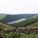
This path went on for quite some time and then came to quite a steep drop down to a stream by the reservoir. The drop was quite a challenge and I probably should have lowered my seat for it!


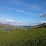
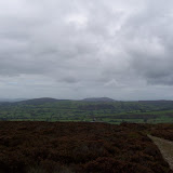
I decided to follow the route clockwise around the reservoir. This wasn't a very interesting path, it was very flat and not much of interest apart from some of the views. I eventually got around the reservoir and continued following the route up a steep path (the same patch I took at the start of the Ladybower loop I had done previously). This patch took me a long some quite rocky terrain, along by the reservoir, and then a nice fast technical descent back down to the pub at the end.


I then had the choice of either following the Ladybower loop that I had done previously or continuing along the current route. I opted to carry on as I wasn't feeling very energetic. The route took me up quite a fast and busy country road and then turned off to the left along a bridle way.

The bridle way took me up quite a steep, very rock and wet path. I had to push my bike most of the way up it but when I got nearly to the top and realised I'd been going the wrong way! I could at least turn around and enjoy the nice technical descent!

The path I should have been following then took me across the road I was going up earlier and up another steep hill when I came across a group of children and a man. It looked like some sort of orienteering trip. The man commented how he'd seen several people coming down the hill I was about to continue up on unicycles! I'd like to see them try and et up it on them!

I then continued up the never-ending hill and eventually got to the top (I was thinking as I was going that the descent at the end better be worth it!)

The path then took a slight down hill and then back up along a short incline. Then the fun started where it suddenly got faster and more rock down back down to the reservoir.

By this point I was quite tired, lacking in energy and very hungry which is unusual as I never normally feel like that on a ride! so I decided to take a detour to the Fairholmes visitor centre for a bacon bap and a coffee.

I then continued the route around the other side of the reservoir and eventually got back to the start of the cut gate path. I had to push my bike up the first section (luckily I found a less steep route to go up then the way I came down.

Then at the top of this steep section there were several more inclines. Whilst they weren't that steep, they were very wet and muddy. It was very slow going and hard work as you couldn't go more than a meter is some places without the back wheel slipping. This was definitely a section for the dry or possibly with mud tyres (I was using summer tyres!). It also didn't help that I was still lacking energy. By the end of it my bike was caked in mud.

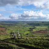
There was a sense of relief as the mud and stream of water stopped and the rocky path began. The following descent made all of the previous hard work worth it however. It was a very fast decent that definitely put a smile on my face!

Unfortunately as I was nearing the end (coming back to the road) I got the inevitable flat tyre. The inner-tube had actually split along the rim. I think I would put this down the the fast rocky section at the end. I did actually try and pump it up again to see if it would last the short trip along the road back to the car but within a few seconds it was flat again.

I then got back to the car, got changed and then started the drive back home.


I didn't take as many photos this time but here are the ones I did take-

Peak District - Cut Gate 2010


Update:

I have just found one reason I was so tired and lacking in energy. It turns out the route I did was 28.5 miles long with 4000 feet of climb! I thought it was only 18 miles.

This is the route I did-
http://www.gpsies.com/map.do?fileId=iavrtmmfsaxzkjlq

Monday 20 September 2010

Long Mynd : Round 3

I currently have two weeks off and so am trying to do as much cycling as possible. I was going to try and go up the the Peak district but after looking at the weather forecast I decided against it. The only place it was raining in the UK as over the peak district! so I opted for the Long Mynd instead.

I headed up Mott's road again (nearly made it all the way to the top this time without stopping!) and then up to Pole Bank where there were several large groups of hikers.

I then continued through the small car park down the steep hill (brilliant views from here), past the farm and up the other side.


Then came the Minton Batch descent; you have got to be very careful here to stay on the path. Stray from the path slightly in some places and your wheel slides down the bank.

When I was nearing the end of this section I managed to get a flat tyre. I fixed this with the spare inner-tube and carried on. The route takes you through a short country land and then up a smooth windy climb back up the the gliding club. Before I got to this climb, I notice something wasn't quite right with the bike; somehow I managed to not put the tyre in the rim properly from the previous puncture and so had a large bulge of inner-tube sticking out between the rim and the tyre so I stopped, deflated the tyre, put it in properly and then re-inflated it.


When I finally got to the top if the windy hill I then past along by the gliding club (some of the best views of the route) and then back to Pole Bank.


Rather than going straight down the grassy bank and along the road, this time I went down the grassy bank and then bared right which took me down quite a challenging path which was quite steep in places. I did struggle a bit on this section but would definitely do it again on the next visit to attempt it again.


It was then just a case of following the road back to the car and starting  the drive home.

I actually logged the route on my GPS. I will post the route as soon as I find somewhere to upload it to.

Update: I have uploaded the GPX log here-
https://sites.google.com/site/mybikeroutesite/LongMyndLoop.gpx?attredirects=0&d=1

More Photos-


Long Mynd 2

Saturday 4 September 2010

Peak District - Ladybower loop

This was my first trip to the peak district. It is an 22 mile loop around Ladybower reservoir starting at the visitor centre.

I set off at 10am and arrived at 12:00. The first climb from the side of the reservoir was quite exhausting but then it levelled out and there were some quite nice views followed by a nice technical rocky downhill section.


It then went pas a pub, along the road, and across the reservoir where I managed to get some nice photos of the damn.


The route followed the roads for a bit up a hill and then a flat section along the side of the hill with some nice views of the surrounding area. I then got to a point where my GPS route split. It  showed the route going back on itself but further up the hill, back down again and continuing the route along the side of the hill. This looked like it could have been a wrong turn by the person who created the route. I decided to follow the route just in case and was glad I did. It lead me up to quite a high-up hill where there were a couple goats and some very nice views.


The track continued down the hill which was quite fast due to the amount I had climbed.


The track then continued until a windy uphill section by a farm followed by a very rock fast downhill section back to the reservoir. I noticed the downhill was starting to get very bumpy and checked my front suspension - I had left the lock-out on from the previous climb! turned the lock-out off and the trail was just as bumpy! I went past a few cyclists coming up who looked liked they wished they were coming down instead; as well as being very rocky, it was also very steep (my wrists were aching from holding the brakes).

I then got back to the the car and the visitor centre at 4.30pm, bought a large coffee and bacon bap, and continued the 2 hour journey home.

The nice thing about this lap was that I wanted to take it slowly to make it last longer (a feeling I don't get at trail centres). I also felt I hadn't gone far enough. I plan on going again but hopefully going a bit further this time.

The route I followed-
http://mtbmonkey.com/Routes/DerbyShire/Ladybower/Ladybower%2020/Ladybower20Image.jpg

GPX of route-
http://mtbmonkey.com/Routes/DerbyShire/Ladybower/Ladybower.zip


Photos:

Peak District - LadyBower Loop 2010

Monday 16 August 2010

Quantocks : Round 2

This is the same as the route below however I followed a long uphill route at the beginning that I saw another rider coming down as I stopped to fix a puncture. (Pinch flat from the previous Downhill). It was fun to come down but very steep (my forearms ached at the end from all the braking.)

I also followed one of the extensions from the "rough ride guide" but I think I followed it the wrong way - was a nice very fast downhill on the tarmac though. (had a close call with a ford KA coming the other way!)

I also didn't start logging the GPX until part way into the journey

Sunday 15 August 2010

Quantocks

This is a nice route but not quite as technical as I would have liked. It had a very nice downhill section at the end down into the valley and then following the stream back to the car park.

I was following a route taken from the Rough Ride Guide South West book.

Thursday 12 August 2010

Dartmoor - Grimspound Hound & Tor : Round 2

I went again mid week (doing the whole route this time) and enjoyed the journey. Some very nice views and some challenging rocky terrain. There were also several nice downhill sections but not as many as I would have liked.

I did get a bit lost though as I was nearing the end of the route (this was the bit I had missed out on the previous visit. 

I was following a GPS route and came to an intersection. The track was pointing to go to the right but I could see the path went straight on (I couldn't see a path on the right). There was also a sign there that said there was a bridle way straight on and one to the right.

I cycled up and down several times but couldn't see the path on the right (through the forest). I decided to head into the forest along what looked like a path that maybe hadn't been ridden for a very long time as it was quite overgrown.

After a while I realised I'd gone the wrong way but it was too late to turn back. I ended up climbing over large boulders (it was literally a case of jumping from one boulder to the next) and dragging my bike over them and through bramble bushes (in my shorts) in order to try and get back to the main track which I should have been on originally.

Luckily I eventually managed to get to the path but I must have been clambering through the forest for about an hour and was exhausted when I got out (it was more tiring that the 25 mile cycle ride) and still had a massive hill to climb.

That is the last time I go down a route that doesn't look like it is a proper/previously ridden path!


Photos:

Saturday 7 August 2010

Dartmoor - Grimspound Hound & Tor

I did this route on my way down to Cornwall. It is a 25 mile route in the north of Dartmoor.

The route I followed-
http://www.gpsies.com/map.do?fileId=iwxfvddrjfgmddef
I did have to take a diversion near the end of the route as I was with my brother who was struggling to keep up so the ride was cut short.

-----------------------------------------------------------------------------------------

A couple of weeks ago I'd purchased a Dakota 20 GPS and found a few GPX files for the south west. It hasn't stopped me getting lost but has made it more difficult to! It would have also taken me a lot longer to plot it out on the OS map and navigate so overall I'm very pleased with it.


Sunday 25 July 2010

Long Mynd : Round 2

Went up again today. Instead of following the road up to the gliding club (coming from Pole bank), I cut through the small car park on the right. There is a brilliant down hill section (and and very good view of the surrounding land) but there is also a not so brilliant uphill climb after (not as bad as Mott's road though).

I then followed the rest of the trail without taking a scenic diversion (getting lost).

I also remembered to take a decent camera (just a shame I forgot to charge it before hand!)

Saturday 24 July 2010

Long Mynd

First time over the Long Mynd. I went up Carding Mill Valley, which was a bit busy but not too bad (it was raining though). The climb up "Mott's Road" was exhausting.

I went slightly the wrong way when I got to the summit (missed Pole Bank) but managed to find the gliding club and the "Minton Batch" descent. I then got a bit lost again coming back up to the gliding club but eventually managed to find "Starboard Way".

I then went back via Pole bank and rather than going down Carding valley again, I went down the middle track (of the three) towards "All Stretton". That was a brilliant (very fast) descent down a grassy bank.

I would definitely like to do this route again (and maybe go the right way next time). If I hadn't got a bit lost then I would have liked to have done the "Minton Batch" again.

I also wish I'd taken a decent camera (only had my mobile on me) as there were some brilliant views.

The route I followed:

Photos:

Long Mynd